


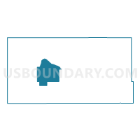
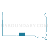
VTD-precinct St.Francis, Todd County, South Dakota
About
Outline

Summary
| Unique Area Identifier | 667804 |
| Name | VTD-precinct St.Francis |
| County | Todd County |
| State | South Dakota |
| Area (square miles) | 72.32 |
| Land Area (square miles) | 72.25 |
| Water Area (square miles) | 0.07 |
| % of Land Area | 99.91 |
| % of Water Area | 0.09 |
| Latitude of the Internal Point | 43.17554020 |
| Longtitude of the Internal Point | -100.90135330 |
Maps

Graphs
Select a template below for downloading or customizing gragh for VTD-precinct St.Francis, Todd County, South Dakota


Neighbors
Neighoring Voting District (by Name) Neighboring Voting District on the Map
- VTD-precinct Bordeaux, Todd County, SD
- VTD-precinct Lakeview, Todd County, SD
- VTD-precinct Parmelee, Todd County, SD
- VTD-precinct Rosebud, Todd County, SD
Top 10 Neighboring County Subdivision (by Population) Neighboring County Subdivision on the Map
Top 10 Neighboring Place (by Population) Neighboring Place on the Map
- Rosebud CDP, SD (1,587)
- St. Francis town, SD (709)
- Spring Creek CDP, SD (268)
- Two Strike CDP, SD (209)